The photography guide to Grand Teton National Park
Grand Teton National Park photography guide
Our contributors have added 20 photo spots to this Grand Teton National Park photo guide. Have you discovered an amazing new location in Grand Teton National Park?
Introduction
Grand Teton National Park offers the best of the American west. The scenery is stunning, the wildlife abundant, and the western-American history thick. All set in a relatively compact area that can yield dozens of outstanding photographs in just a day; though to fully explore and photograph the park, a full week is recommended.
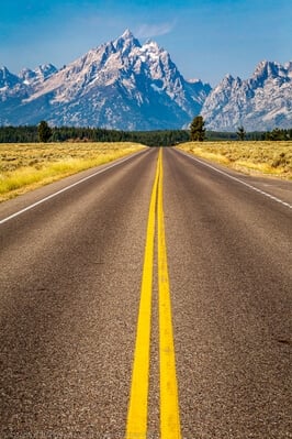
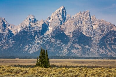
The highlight of the park is the Grand Teton mountain range, which rises some 7,000 feet above the valley floor of Jackson Hole. What makes the range so dramatic is the abruptness of their rise, with the crest of the range, Grand Teton itself, being a short 3.5 miles west of the edge of the valley. Visible from most areas of the park, the Tetons are stunning. Below the mountains on the valley floor are numerous lakes and the Snake River, both which provide wonderful foregrounds for the mighty mountains beyond.
Jackson Hole is teeming with wildlife. Commonly seen animals include: moose, elk, mule deer, grizzly and black bears, beaver, wolves, bison, bighorn sheep, pronghorn antelope, mountain goats, bald and golden eagles, trumpeter swans, white pelicans, osprey and other hawks, and more.
Essentially, the park can be divided up into four major zones: the mountains, western Jackson Hole, eastern Jackson Hole, and the area north of Jackson Hole. The mountains are spires of granite. There are many trails in the mountains chock full of high country scenery.
Western Jackson Hole is at the base of the southern portion of the range. The land is a mix of trees and meadows, scattered with lakes and streams, including Jenny Lake, Leigh Lake, and the southern end of Jackson Lake. This area is accessed by Teton Park Road, which runs from Moose Junction in the south to Jackson Lake Junction in the north. Photo spots in western Jackson Hole include Jenny Lake, String Lake, Chapel Bay, and Signal Mountain.
The eastern portion of Jackson Hole is a broad sagebrush plain with scattered stands of evergreens and aspen trees. The Snake River meanders through a shallow valley across the plain. Many of the best photographic spots are located in this portion of the park, including the barns on Mormom Row, Schwabacher Landing, and the Snake River Overlook. Eastern Jackson Hole is accessed by US Highway 26/89/191 (a single roadway where three separate US highways merge). Because the highway is the major transport route between Debois and Jackson, Wyoming, it can be driven without paying an entry fee.
The central and northern portions of Jackson Lake are in the northern section of the park. West of Jackson Lake is the northern portion of the Teton Range, which are generally not as steep and tall as the southern portion. East of the lake is forest lands which continue east of the park into the Teton Wilderness. This portion of the park is accessed by US Highway 89/191/287. An entrance fee is required for this portion of the park. Because of the forest and limited access to the lakeshore, there are fewer photo spots in this portion of the park, though the southern end of it includes Willow Flats and, perhaps the most popular photo spot in the park, Oxbow Bend.
The area was first visited by Native Americans more than 12,000 years ago, who hunted and used Jackson Hole as trading grounds. French fur trappers were the first non-natives to explore the area, naming the three highest mountains in the range Les Trois Tetons (which translates to “the three breasts”). In 1807, the first American arrived in the area, when John Coulter, a member of the Lewis and Clark Expedition, explored the area. Soon thereafter, an American fur trapper named Davy Jackson started working in the Snake River valley in front of the Tetons. Mountain men referred to such mountain valleys as “holes” and the area became known as Davy Jackson’s Hole, later shortened to Jackson’s Hole.
The first known photographs were taken by Willian Henry Jackson in 1878 as part of the Hayden Surveys of the northern Rockies. The first settlers arrived in 1884. In 1889, the first Mormon families arrived and established Mormon Row. In the early 1900’s, wealthy Americans started visiting Jackson Hole for adventure. As a result, ranching of “dudes” became more profitable than cattle. With the tourist trade, talk began of making the area a national park to protect it from uncontrolled development. Grand Teton National Park was formed in 1929, but it only included the mountains. Jackson Hole became a less protected reserve.
John D. Rockefeller, Jr. recognized the potential for Jackson Hole to become over commercialized, and quietly started buying up land with the intention of donating it to the national park. He eventually acquired about 35,000 acres. Rockefeller’s acreage, along with the rest of the federal land in the valley, was named the Jackson Hole National Monument in 1943. In 1950, it was combined with the park to become the present-day Grand Teton National Park.
Most popular Grand Teton National Park photo spots


Travel
To make the most of your visit to Grand Teton National Park, you will want to have your own vehicle or share a car with a fellow photographer. The best time to photograph in the park is the morning golden hours, so you will be making an early start from your campsite or hotel.
Grand Tetons National Park has five campgrounds and one RV park. Only group campsites and the spots in the RV park are eligible to be reserved. All other campsites are available on a first-come first-serve basis, and during the high season, the campgrounds fill up early. The various campgrounds close for the season on different dates starting in mid-September and ending in mid-October.
Gros Ventre (pronounced grow vaunt) is the largest campground and typically last to fill up. It is well placed for shooting at Mormon Row, Antelope Flats, Schwabacher Landing, the Snake River Overlook, and the Chapel of the Transfiguration. The Jenny Lake (tents only) and Signal Mountain campgrounds are conveniently located to shoot at Jenny and String Lakes, Chapel Bay, Signal Mountain, Willow Flats, and Oxbow Bend. The Jenny Lake campground is also the closest to many of the most popular trails. Coulter Bay campground is located fairly near to Willow Flats, Oxbow Bend, Chapel Bay, and Signal Mountain.
There are additional campgrounds nearby and outside the park. There are several US Forest service campgrounds east of the park on Gros Ventre Road and US Highway 26/287. Dispersed camping is also allowed in most areas of Bridger-Teton National Forest east of the park.
There are several lodges and dude ranches available for overnight stays within the park. The town of Jackson is about 12 miles south of the park headquarters at Moose and has dozens of motels and other lodging options.
The closest major city is probably Salt Lake City, Utah; about a 4.5 hour drive away. However, Jackson has a commercial airport with daily flights and car rentals.
Top Picks
Because Jackson Hole is located east of the Teton Range, the best time for photography is from about a half hour prior to sunrise until about two hours after sunrise, and all the top picks described below are best shot at those times except for Antelope Flats Wildlife. Because the morning golden hours are the best times for all these spots, hitting them all in a single day is problematic.
However, with a bit of luck, it is possible to bring home good shots from all the top picks listed below in a single day. The suggested itinerary below is a variation on one suggested by Teton photographer Daryl L. Hunter in his book Grand Teton Photography and Field Guide. The total drive time on the itinerary below from Schwabacher’s Landing to the top of Signal Mountain is about 1 ¾ hours not including time for photography, so don’t spend too much time at any one spot if you hope to shoot them all in good morning light. A far better plan would be to spend several days to a week in the park, visiting these top sunrise spots on different days. The final top pick, Antelope Flats Wildlife, can be visited in the morning or afternoon.
Schwabacher Landing
The view of the Tetons from Schwabacher Landing is one of the classic Teton shots. There are actually two great spots here, one immediately below the parking area where a channel of the Snake River provides reflections of the mountains and the other a 5-minute walk to the north to a beaver pond. The shot from the beaver pond is perhaps the more popular, but there are also fewer spots to set your tripod there. Both spots are extremely popular with photographers at sunrise, so get here extra early. But don’t stay too long if you want to hit all the spots below in good light. Once the sunlight nears the base of the peaks, head back to the car and drive to Morman Row.
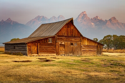
Mormon Row Barns
There are two scenic, old log barns on Mormon Row, the John Moulton Barn, just north of the intersection of Antelope Flats Road with Mormon Row, and the T.A. Moulton Barn, a short distance south on Mormon Row. If your timing is good, you’ll reach these old barns just as the morning sun is lighting them. Shoot each of the barns from the southeast to line up these historic barns with the mountains in the background. From here jump back in your car, drive back out to the highway, and head north (past the turn to Schwabacher Landing) to the Snake River Overlook.
Snake River Overlook
The view from the Snake River Overlook may be the most recognizable view of the Grand Tetons due to Ansel Adams’ famous photograph taken from this spot. Unfortunately, the view is not quite so good today because the trees between the viewpoint and the Snake River have grown quite a bit since Mr. Adams shot here in the 1940s, but it is still one not to be missed.
Oxbow Bend
From the Snake River Overlook, continue north then turn left at the Moran Junction and go on through the Moran Entrance Station. In another 13 miles you will reach another iconic view. Oxbow Bend is a side channel of the Snake River which forms a broad curving waterway in which Mount Moran is perfectly reflected. You have various compositions to try here, shooting by the road and looking down on the water or going down to the shoreline for a different look. Also try zooming in on Mount Moran and its reflection. But don’t take too long if you want to get to Jenny Lake before the morning wind ruins the reflection there.
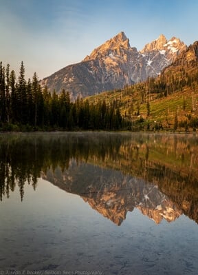
Jenny Lake
From Oxbow Bend continue north on the highway and then turn left onto Teton Park Road at Jackson Lake Junction. Continue on Teton Park Road for about 10 miles and turn right onto Jenny Lake Road. If you already suspect the wind may be ruining the reflection on Jenny Lake, try String Lake instead since it is smaller and more protected than Jenny Lake. Turn right on String Lake Road to reach StringLake or continue straight to go to Jenny Lake. After the road becomes a one-way road, look for the Jenny Lake viewpoint on your right. Park and scramble down the rough path south of the viewpoint to the shoreline to capture the mountains and their reflection in the remaining morning light.
Chapel Bay
After leaving Jenny Lake, turn left on Teton Park Road and continue back the way you came, stopping at the pull over at Chapel Bay (which you passed on the way to Jenny Lake). The reason to shoot here after Jenny Lake is that the lake water at this spot often gets calm several hours after sunrise. Here the scene is of the broad Teton Range with Jackson Lake in the foreground. You can shoot from either the sidewalk by the parking area and/or by heading down the short steep bank to shoot by the lakeshore. When done here, turn your car around and drive south once again on Teton Park Road to Signal Mountain.
Signal Mountain
After a short 4 miles winding up Signal Mountain Road, you will reach Jackson Lake Overlook located at a hairpin curve not quite on top of the mountain. Walk the short trail to the overlook to treat yourself to a view of Mount Moran overlooking Jackson Lake. While up on the mountain, you may wish to drive to the end of the road to see the viewpoint that looks easterly and southeasterly onto Jackson Hole (though the light for photography from this spot will be better in the late afternoon).
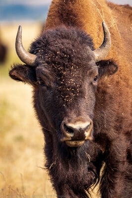
Antelope Flats Wildlife
If you shot from all the spots listed above in a single morning, you deserve a break. After driving back down Signal Mountain, stop by the Signal Mountain Lodge for a coffee or a milkshake. Then you have one more top pick left, the bison and pronghorns at Antelope Flats. Make your way back to Antelope Flats Road and put your telephoto lens on the camera. Then drive the loop made by Antelope Flats, Mormon Row, and Gros Ventre Raads looking for animals. The bison herd is often easy to see in the distance as brown spots on the prairie. Pronghorns blend in much better and you may need to look carefully to find them. If the bison herd is far from the road, try coming back later in the day, as the herd moves around quite a bit.
Seasons
Grand Teton National Park is available for photography year round. The winters are cold in Jackson Hole; the first snow falls usually by November 1st and snow usually lingers on the ground until April (however, snow and frost are possible during any month). The US highways are plowed during the winter (at least north to Flagg Ranch), providing access to many scenic spots including Oxbow Bend and the Snake River Overlook. Between the snow storms the days are often sunny, but cold. The average high temperature in January is -1o C and the average low is -17o C. Wildlife is commonly seen crossing the roads in winter and the elk congregated in the National Elk Refuge at the south end of the park.
Spring arrives in mid-April and runs through June. The days are milder and the nights cool. The average high in May is 61o C and the average low is 31o C. Trails in the valley are usually snow-covered until mid-May. Wildflowers are abundant in the valley in mid-spring to early summer.
July and August bring summer weather with warm days; the average high in August is 79o C and the average low is 40o C. Afternoon thunderstorms are common, bringing with them many photographic opportunities for dramatic skies. Of course, this is also peak tourist season, and you will rarely be alone at any of the major photographic spots.
Autumn arrives by mid-September and lasts into November. The peak fall color is usually in late September and early October, when the aspens turn brilliant yellow. This is also a very popular time for photographers to visit the park. The weather is cooler; the average high in October is 56o C and the average low is 23o C. September is the rutting season for the elk and moose; you will be able to hear the eerie sound of elk bugling on many mornings.
Responsible Photography
Grand Teton National Park is part of the Greater Yellowstone Ecosystem, which according to the National Park Service, is one of the largest nearly intact temperate-zone ecosystems on Earth. As such, photographers should take extra responsibility to care for this special place. Be aware of your potential impact on the landscape and ecosystem as you drive, hike, and photograph.
Please take care to follow all rules, regulations, and guidelines, even if that means not getting the shot. For example, some locations are signed for no off-trail access due to overuse and sections of some roads are marked as no parking or stopping (including along Moose-Wilson Road, one of the best places to see wildlife in the park). Respect these rules, leave your camera in its bag, enjoy the view, and go elsewhere to do photography.
Many of the favorite photographic spots can become crowded during the prime times. Please be respectful of others, and if too crowded, consider coming back at a later time. When stopping on park roads, use pull outs where available, and where not available, pull completely onto the shoulder to keep roads clear. Remember that wildlife are wild. Rather than approaching them, use a telephoto lens. Be aware of your surroundings, including behind you, and if wildlife approach you, grab your camera and get back in your car.
Links
Official Grand Teton National Park Website
Information on more than 45 hikes in the park complete with photos, difficulty rating, and elevation profiles
Jackson Hole live webcams
Website of the Bridger-Teton National Forest (located immediately east of Grand Teton National Park)
Curated By

Joe Becker Curator
We hope you enjoy this guide to photographing Grand Teton National Park - don't forget to share your images on PhotoHound and tag us on social media using hashtag #photohound


