The photography guide to
 Mount Rainier National Park
Mount Rainier National Park photography guide
Our contributors have added 64 photo spots to this Mount Rainier National Park photo guide. Have you discovered an amazing new location in Mount Rainier National Park?
Introduction
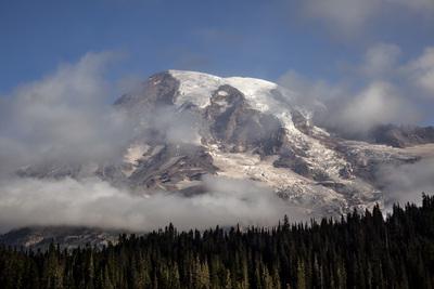
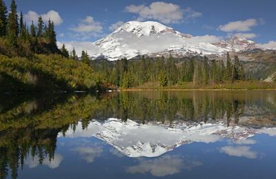
Mount Rainier National Park, located in Washington State, covers an area of 236,381 acres on and around Mount Rainier, which at 14,411 feet (4,392 meters) is the tallest mountain in the Cascade Range. Though currently dormant, with its most recent eruption about 1,000 years ago, Mt. Rainier is considered an active volcano. It is a land of stunning beauty and highly diverse landscapes. The national park was established in 1899, and is a UNESCO World Heritage Site.
The park is a popular destination for outdoor enthusiasts, including photographers. The park offers many scenic views of “The Mountain”, as Rainier is lovingly called by many Washingtonians. The snow- and glacier-clad mountain (it is the most glaciated peak in the contiguous United States) and the surrounding meadows and forests, provide endless opportunities for landscape photography. In summer, the alpine meadows are washed with color from wildflowers (the park is home to more than 300 different flower species). Wildlife, including deer, elk, black bears, mountain goats, and many birds and small mammals, are frequently seen. Besides Mount Rainier, the park also contains a portion of the Cascade Mountains and the Tatoosh Range (a sub-range of the Cascades).
Most popular Mount Rainier National Park photo spots


Travel
The easiest way to get to the park is by car; the drive to the Nisqually Entrance to the park (the most popular entrance and the only one open year-round), takes about two hours from Seattle. Overall, there is good road access to many places in the park. State highways (closed in winter) provide access to the eastern side of the park. Highway 121 travels north from the Ohanapecosh area in the southeast portion of the park to Cayuse Pass, where it intersects with Highway 410. Highway 410 enters the northeastern portion of the park along the White River before climbing up to Cayuse Pass. From there it turns eastward and climbs higher, before leaving the park near the very scenic Tipsoo Lake at Chinook Pass. A paved spur road (Sunrise Park Road) leaves Highway 410 to climb to Sunrise, at about 6,400 feet (1,950 meters) the highest point accessible by car in the park, providing good access to the alpine areas northeast of the mountain.
The southern side of the mountain has good road access off of the paved Paradise/Stevens Canyon Roads. Paradise Road starts at the Nisqually Entrance in the southwest corner of the park, travels by Longmire before heading uphill to Paradise (at about 5,400 feet/1,645 meters). This road is typically open year-round (it may be closed on weekdays past Longmire in the winter; check with the Park Service for winter hours). Past Paradise, the road changes names to the Stevens Canyon Road, which travels by the scenic Reflection Lakes, then traverses downhill along Stevens Canyon before intersecting with Highway 121 near Ohanapecosh.
The other major road in the park accesses the Mowich Lake area in the northwestern corner of the park. Mowich Lake Road is also closed in winter.
There are two other roads in the park that are open to biking and hiking, but are mostly closed to vehicular traffic.Both these roads were closed due to repeated erosional events destroying the roadways. The Carbon River Road is open to the Carbon River Ranger Station at the extreme northwestern corner of the park, but is closed past that point. The West Side Road is a spur off of Paradise Road near the Nisqually Entrance, but it is only open to cars for about three miles.
There are hundreds of miles of hiking trails accessible off of the roads, providing access to the wilderness areas around the mountain. Many of the most beautiful photo spots in the park can only be accessed on foot. The most famous of the trails in the park is the 93-mile long Wonderland Trail, which circumnavigates the mountain.
Top Picks
Paradise: Paradise is the most visited area in the park for a good reason: gorgeous views of The Mountain as well as the Tatoosh Range, amazing wildflowers, and multiple short trails leading to other fantastic views. Unlike most other areas in the park, road access to Paradise is open year-round.
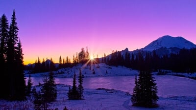
Sunrise: At an elevation of 6,400 feet (1,950 meters), Sunrise is as high as you can drive in the park. The Mountain looks distinctly different here than at Paradise, and true to its name, the view of Rainier, as it is painted by the rising sun, is fantastic here. This is also a great spot for night photography.
Tipsoo Lake: This small lake on the crest of the Cascade Mountains east of Rainier is one of the premier sunrise locations in the park. It is also known for its wildflower meadows and for bright autumn colors.
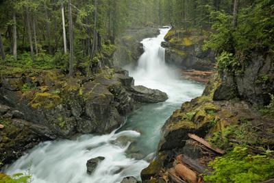
Silver Falls: There are over 100 waterfalls in Mountain Rainier National Park, and Silver Falls is one of the best. Here the very scenic Ohanapecosh River drops 40 feet (12 meters) into a large blue plunge pool before entering a steep gorge crossed by a rustic footbridge. Besides photographing the falls, you can explore the trail upriver from the falls for additional photo opportunities along the river.
Indian Henry’s Hunting Ground: The backcountry around Rainier has many great wildflower meadows, Indian Henry’s Hunting Ground offers mountain reflections in several small lakes and great autumn color as well as summer wildflowers.
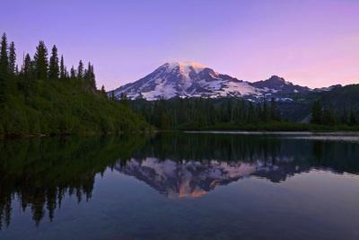
Bench Lake: Most people stop at Reflection Lakes to look for a good reflection of The Mountain, and these lakes reputation is well deserved. But just a short hike away, Bench Lake offers, perhaps, better reflections with lesser crowds.
Comet Falls/Van Trump Park: Dropping over 400 feet (122 meters) in four tiers, Comet Falls is perhaps the prettiest waterfall in the park. It is reached by a 1.4 mile (2.25 kilometers) trail. After visiting the falls, consider continuing your hike above the falls to Van Trump Park for mountain views and wildflowers.
Christine Falls: Don’t want to hike to see a great waterfall? Then Christine Falls is for you, with the view only steps from the car. While the classic shot here is the falls framed by a stone bridge, be sure to also shoot from the bridge for a view of the falls less often seen.
When To Go
The best weather at Mount Rainier is mid-summer to early fall. Days are often sunny and temperatures can be warm (though the weather can turn cold rapidly anytime of year at higher elevations in the park). The prime time is wildflower season in the alpine meadows, typically in early to mid-August. By September, many of the smaller tarns and lakes can dry up, but fall brings autumn color to many locations in the park. Once the snow hits, often in October, high country access becomes limited and the roads within the park close except for the road to Paradise.
Paradise is known for its snowfall. It averages 53.3 feet (16.2 meters) each winter, providing great photographic opportunities. Needless to say, it can be cold and is often cloudy, but sunny days in the winter and early spring at Paradise can be magical.
As the weather warms up in late spring and early summer, the snowmelt provides ample runoff for the waterfalls, so much that the sheer volume of water can overwhelm some of their best photographic features and create problems with mist. Meanwhile, while access returns to some of the high country at this time of year, the alpine meadows are their least photogenic when only partially melted out.
Responsible Photography
As a photographer, it is important to be mindful of your impact on the landscape and ecology and to be careful not to destroy the very reason you are there. The ecology of the sub-alpine and alpine areas of the park are fragile. In many of the most visited areas, off-trail travel is prohibited to protect fragile plant life. Please stay on the trails in areas so posted. In areas that are open to cross-country travel, take care to limit your impact on the plants and wildlife. Use minimal-impact techniques when setting up equipment and do not disturb plants or rocks to create better compositions. When hiking and backpacking, pack out what you pack in. Remove all trash and leave no trace of your visit. Camp only in designated backcountry campsites or areas.
The park is very popular and gets millions of visitors each year, mostly in the summer. Please be respectful of other visitors who are also trying to enjoy the park just like you. Try to avoid obstructing trails when others are present; be willing to move your tripod aside when others need to pass.
If visiting in winter or early spring, be aware of avalanche danger. Avalanches present not only a danger to you, but to other visitors on the slopes below you should you set one off. Be trained in traveling in avalanche-prone areas and review avalanche forecasts prior to traveling in the backcountry during winter and early spring.
Links
Mount Rainier National Park official website
Washington Trails Association Mount Rainier Hikes
University of Washington Weather Service
NPS Weather Service
Northwest Avalanche Center avalanche forecasts
Explore more photo spots in United States
If you want to explore beyond Mount Rainier National Park, we have 1880 photo spots and 15 events that you can visit in United States.
Curated By

Joe Becker Curator
We hope you enjoy this guide to photographing Mount Rainier National Park - don't forget to share your images on PhotoHound and tag us on social media using hashtag #photohound


