Explore the top spots in
 Zion National Park & Surroundings
41 photo spots 226 inspiring images 10 contributors
Top places to photograph in Zion National Park & Surroundings in 2024
These are the very best Zion National Park & Surroundings Instagram spots, curated by the PhotoHound team. If you've got limited time here, these are the must-see locations to shoot while you're in Zion National Park & Surroundings!
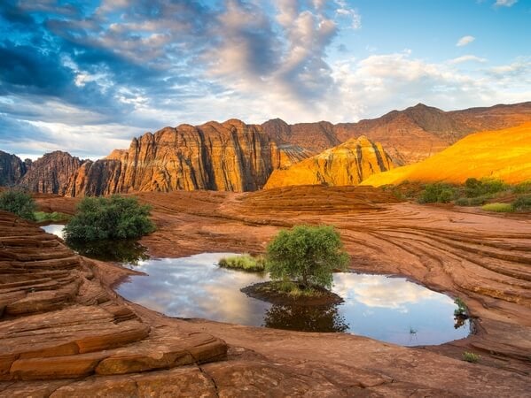
Snow Canyon
More than any other park, Snow Canyon State Park offers a concentration of many formations and geological features that can be found in the American Southwest; you could call it a Colorado Plateau redux.
Despite its relatively small acreage, Snow Canyon packs a tremendous punch of extremely scenic spots along its 4-mile long Scenic Road and numerous trails: intensely colorful sandstone cliffs ranging from white to deep red, cross-bedded domes alternating with black lava fields and tunnels, finely eroded slickrock, lovely pink sand dunes, arches, slot canyons, and great views from several easily-reached promontories. All this results in excellent photographic opportunities.
Snow Canyon has seen its visitation skyrocket in recent years due to a steady influx of population in the neighboring St. George area. It has also benefited from the popularity of outdoor sports such as running, cycling, and rock climbing as well as several nearby spa resorts specializing in weight reduction (ex: The Biggest Loser, Red Mountain Spa, etc.)
Learn more about Snow Canyon
Despite its relatively small acreage, Snow Canyon packs a tremendous punch of extremely scenic spots along its 4-mile long Scenic Road and numerous trails: intensely colorful sandstone cliffs ranging from white to deep red, cross-bedded domes alternating with black lava fields and tunnels, finely eroded slickrock, lovely pink sand dunes, arches, slot canyons, and great views from several easily-reached promontories. All this results in excellent photographic opportunities.
Snow Canyon has seen its visitation skyrocket in recent years due to a steady influx of population in the neighboring St. George area. It has also benefited from the popularity of outdoor sports such as running, cycling, and rock climbing as well as several nearby spa resorts specializing in weight reduction (ex: The Biggest Loser, Red Mountain Spa, etc.)
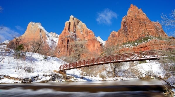
Court of the Patriarchs
Zion Canyon reveals its entire splendor slowly as the sun climbs over the surrounding peaks. You can photograph from two viewpoints: the main one takes you on a short climb to an elevated viewpoint. The other one is 0.1 miles along the service road across the street.
Learn more about Court of the Patriarchs
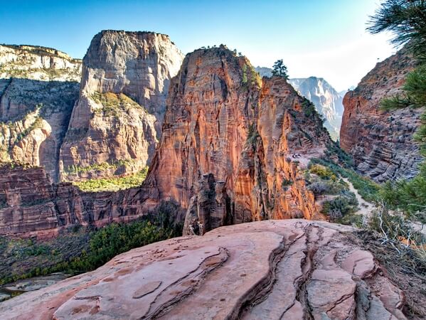
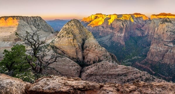
Angels Landing
Due to its central location, this is the most beautiful view of Zion Canyon. To access it requires good physical condition and some exertion, but above all, you shouldn’t have fear of heights. Most people in average condition can do this hike by pacing themselves, but don’t push it if you feel dizzy in the chains section and exercise caution at all times. This hike is exhilarating, but keep you attention on the trail; every year brings its load of accidents, some fatal. You will need about 3 hours round-trip to hike and photograph Angels Landing.
The vista from the top of Angels Landing is sensational and well worth the effort. You can see the entrance to Zion Canyon opening up to the right, while in the center you get a breathtaking view of the Great White Throne. To the left, the canyon meanders toward the Temple of Sinawava.
Learn more about Angels Landing
The vista from the top of Angels Landing is sensational and well worth the effort. You can see the entrance to Zion Canyon opening up to the right, while in the center you get a breathtaking view of the Great White Throne. To the left, the canyon meanders toward the Temple of Sinawava.
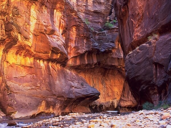
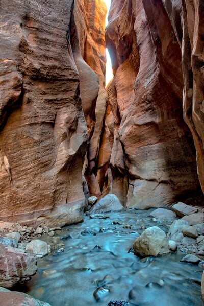
The Virgin Narrows
One of the main draws of the Virgin Narrows is the fact that you are almost constantly immersed in the Virgin River, often up to your knees and occasionally higher. This contributes enormously to the high fun factor of this great hike, although it may be quite strenuous when the water level is high (especially when walking upstream against the current). Permits are not required for day-hikers.
Learn more about The Virgin Narrows
Deertrap Mountain
Deertrap Mountain offers an alternative view of the lower main canyon from the East Rim. Although not in the same league as Angels Landing or Observation Point, the view encompasses highlights such as the Towers of the Virgin, the Three Patriarchs, and Mountain of the Sun, that the others don’t.
Learn more about Deertrap Mountain
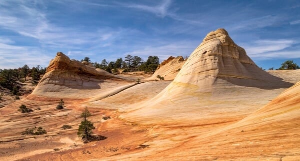
The White Domes
This hike or backpacking trip leads to the top of Canaan Mountain, a vast plateau extending from the Arizona Strip in the South to the Virgin River Valley in the north. From a landscape photography stance, the interest is principally the area called the White Domes: a series of strikingly white sandstone domes rising from the surrounding colorful sandstone. One of the domes has wave-like curves reminiscent of the uber-famous Wave in the Coyote Buttes and some have started calling it the White Wave.
Learn more about The White Domes
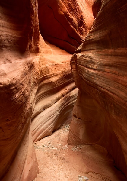
Peekaboo Canyon
Peekaboo Canyon (formerly known as Red Canyon) consists of two short but beautiful sections of twisted narrows, no longer than 200 feet each, with good photographic potential and no water holes or obstructions of any kind. 2-½ hours is enough for the drive and visit.
Learn more about Peekaboo Canyon
Kanarra Creek
The hike through the Kanarra Creek Narrows is a fun, easy, and highly rewarding way to experience the typical feeling of a slot canyon with tall red walls, lots of shallow water crossings, nice waterfalls, and lovely reflected light. It can be challenging for some people, however, as they will find two difficult passages with slippery ladders. Allow 2 to 2-½ hours out and back to the Lower Falls and 3-½ to 4-½ hours for the almost 5-mile Upper Falls round-trip, with plenty of time for photography.
The hike follows the gated dirt road for about a mile from the car park, before joining the creek. From here on, you walk alternatively on the banks and in the stream bed, crossing the creek multiple times before encountering the narrows after about 0.75 miles. After a short section of narrows you'll come to the first of the Lower Falls (actually a rock jam) which presents the first obstacle, at mile 2.3. A ladder is conveniently wedged on the right side of the falls, with steps for you to climb on and a rope to hang on to. Although there is no guarantee that this ladder will still be there by the time you read this, chances are there will be something in place to help you negotiate the 15-foot drop. This hike is extremely popular with the locals, especially on weekends and in summer, so you may have to wait in line to climb the ladder. In any case, it's bound to be wet and slippery, so watch your step when climbing up and back down. After passing this obstacle, you'll find the second of the Lower Falls almost immediately,consisting of a lovely cascade. Most people turn around here. By scrambling up on the right side you can reach the next level without too much difficulty and continue to the Upper Falls (37.544016°, -113.140046°). In a rainy year, this section may require you to walk in thigh-high, possibly very cold water.
Learn more about Kanarra Creek
The hike follows the gated dirt road for about a mile from the car park, before joining the creek. From here on, you walk alternatively on the banks and in the stream bed, crossing the creek multiple times before encountering the narrows after about 0.75 miles. After a short section of narrows you'll come to the first of the Lower Falls (actually a rock jam) which presents the first obstacle, at mile 2.3. A ladder is conveniently wedged on the right side of the falls, with steps for you to climb on and a rope to hang on to. Although there is no guarantee that this ladder will still be there by the time you read this, chances are there will be something in place to help you negotiate the 15-foot drop. This hike is extremely popular with the locals, especially on weekends and in summer, so you may have to wait in line to climb the ladder. In any case, it's bound to be wet and slippery, so watch your step when climbing up and back down. After passing this obstacle, you'll find the second of the Lower Falls almost immediately,consisting of a lovely cascade. Most people turn around here. By scrambling up on the right side you can reach the next level without too much difficulty and continue to the Upper Falls (37.544016°, -113.140046°). In a rainy year, this section may require you to walk in thigh-high, possibly very cold water.
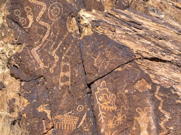
Parowan Gap Petroglyphs
The Parowan Gap is a rather short fault of volcanic origin running across a long sandstone ridge rising out of the desert bed, northwest of the Parowan township. 2 hours round-trip from Parowan should suffice to shoot the Zipper Glyph Panel and a few other panels.
Learn more about Parowan Gap Petroglyphs
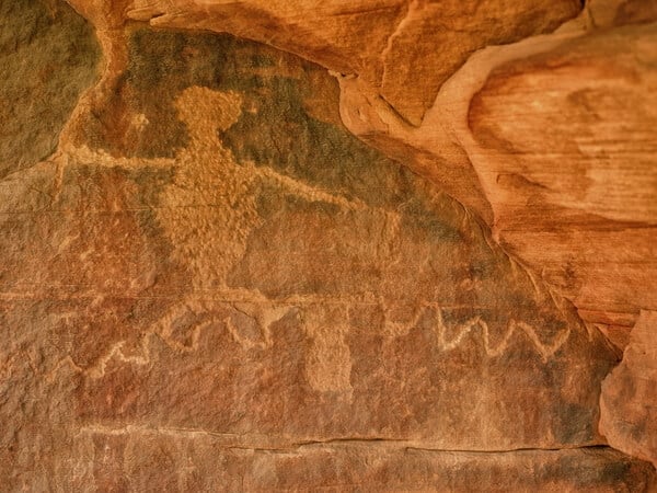
Petroglyph Canyon
This is a leisurely half-mile walk to “secret” Petroglyph Canyon. Well, not quite a secret, but it is Park policy not to talk about it unless you mention it by name to a Ranger. The glyphs are pecked at eye level or below along a 70-foot length of soft, colorful sandstone.
Learn more about Petroglyph Canyon
We hope you enjoy photographing these great Zion National Park & Surroundings Instagram locations. We love seeing your images of the most Instagrammable places in Zion National Park & Surroundings, so make sure to share your images on PhotoHound and tag us on Instagram @photohound and hashtag #photohound for a chance to be featured.


