Aqueduto das Águas Livres
1 images 1 contributors Shoot freely
Sue Wolfe
About this spot
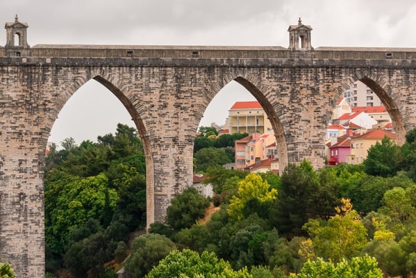
Aqueduto das Águas Livres is an example of 18th-century engineering. The main course covers 18km, but the whole network of canals is 58 km.
While Lisbon sits on an estuary, the Tagus River is brackish, making it unsuitable for drinking. The Alfama neighborhood was the only area with reliable spring water. As the city grew, a different source had to be found. The king instituted a tax in 1620 to raise funds for the aqueduct system but it wasn’t until 1729, after another tax increase, that plans began to take shape.
Construction began in 1731 and the arches over the Alcantara Valley were completed in 1744. A total of 35 arches spans the valley—with the world’s tallest pointed stone arch reaching 65 meters. The water started flowing in 1748 and amazingly the aqueduct remained intact during the 1755 Earthquake. The aqueduct remained operational until 1967 and was officially decommissioned in 1968.
The Aqueduto das Águas Livres was placed on the UNESCO “tentative list” in 2017 due to its cultural and engineering value.
Join PhotoHound to learn how, where and when to capture amazing photos here
- Know the best times, seasons & shooting conditions
- Detailed directions - maps, co-ordinates and directions
- Know how to get there - where to park or how to reach there using public transport
- Browse inspirational photos and learn how they were taken - see the EXIF details
- Bookmark your favourite spots for future reference
- Know exactly when to shoot for beautiful photographs - sunrise, sunset, blue hour and astrophotography
- Detailed, 7-day weather forecast at this location
- Share your images with like-minded travel photographers
Essential Information
Guides
This spot appears in 1 guide.