Explore the top spots in
 The Peak District
106 photo spots 346 inspiring images 24 contributors
Top places to photograph in The Peak District in 2024
These are the very best The Peak District Instagram spots, curated by the PhotoHound team. If you've got limited time here, these are the must-see locations to shoot while you're in The Peak District!
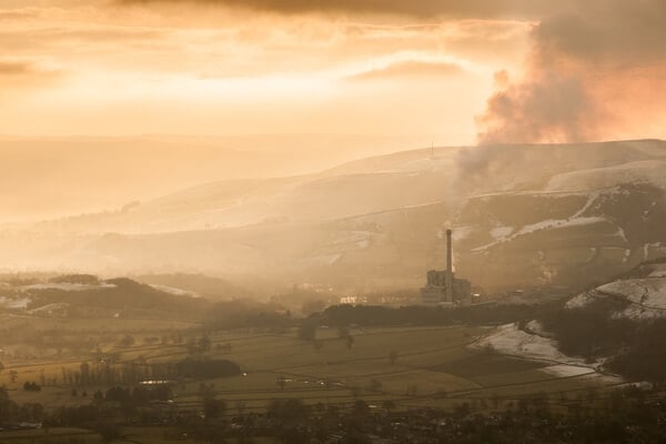
Mam Tor Summit
Mam Tor, for most, is the pinnacle of
photography locations in the Peak District.
It boasts easy to access elevated views
of the often mist-lined valleys below.
This mecca for photography ensures on
any given day you are likely to have the
company of several photographers.
The 517m high hill is known locally as
‘The Shivering Mountain’. Due to its rock
composition of shale, it is very unstable and has frequent landslips. So much so, the A625 which used to be underneath Mam Tor is now permanently closed to vehicles.
From around 1200 BC, Mam Tor also used to be an Iron Age hill fort, which is clearly evident when viewed from the neighbouring Rushup Edge, and the ramparts can be clearly seen
circling the hillside.
Learn more about Mam Tor Summit
photography locations in the Peak District.
It boasts easy to access elevated views
of the often mist-lined valleys below.
This mecca for photography ensures on
any given day you are likely to have the
company of several photographers.
The 517m high hill is known locally as
‘The Shivering Mountain’. Due to its rock
composition of shale, it is very unstable and has frequent landslips. So much so, the A625 which used to be underneath Mam Tor is now permanently closed to vehicles.
From around 1200 BC, Mam Tor also used to be an Iron Age hill fort, which is clearly evident when viewed from the neighbouring Rushup Edge, and the ramparts can be clearly seen
circling the hillside.
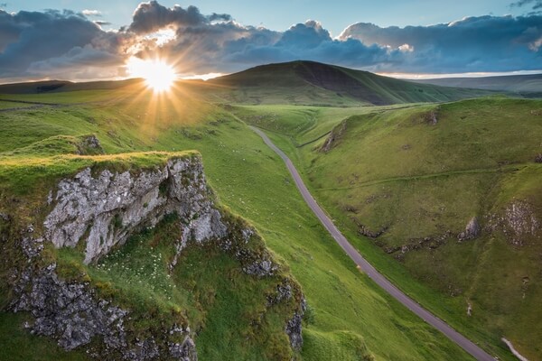
Winnats Pass
Winnats Pass, meaning ‘Windy Gates’ is a
dramatic, steep-sided limestone ravine that was once a coral reef leading west out of Castleton. Since the closure of the A625 below Mam Tor (aka ‘The Broken Road’) it has been the only way out of Castleton to the west.
Pointy fingers of limestone tower above the road on both sides as you drive up. This makes it one of the most dramatic locations in the Peak District. From the tops of the pass you are afforded great views to the landslip on Mam Tor,
‘The Great Ridge’ and the Hope Valley as well as fearful drops to the pass below.
This location was once a rarely shot haven for photographers but is gaining more popularity. If you’re a brave soul you will capture unique and stunning images by standing very close to or even leaning over the precarious edges - but take care here!
Learn more about Winnats Pass
dramatic, steep-sided limestone ravine that was once a coral reef leading west out of Castleton. Since the closure of the A625 below Mam Tor (aka ‘The Broken Road’) it has been the only way out of Castleton to the west.
Pointy fingers of limestone tower above the road on both sides as you drive up. This makes it one of the most dramatic locations in the Peak District. From the tops of the pass you are afforded great views to the landslip on Mam Tor,
‘The Great Ridge’ and the Hope Valley as well as fearful drops to the pass below.
This location was once a rarely shot haven for photographers but is gaining more popularity. If you’re a brave soul you will capture unique and stunning images by standing very close to or even leaning over the precarious edges - but take care here!
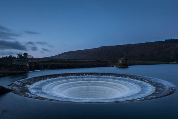
Ladybower Plughole
Ladybower Reservoir is a large Y-shaped
reservoir in the Upper Derwent Valley near
Bamford. It is a beautiful location and easily
accessible by all. At times you would be
forgiven for forgetting that the area was
crafted by man. It is perhaps one of the closest
examples to a lake the Peak District has.
Ladybower wasn’t constructed without
controversy. Built between 1935 and 1943, it
was built to provide water to Manchester and
Sheffield as well as the East Midlands.
It continues to fulfil this role to this day. However, this was at the cost of the villages of Ashopton and Derwent.
The buildings were demolished except for the
church, which could be seen during low water
until 1947 when it was also demolished.
At the north of Ladybower is Derwent Reservoir.
The reservoir’s dam was used as practice runs
for the Dam Busters in World War II, due to the
similar construction of the German dams.
Roughly every 5 years an anniversary flight passes over Derwent and Ladybower Reservoir.
Learn more about Ladybower Plughole
reservoir in the Upper Derwent Valley near
Bamford. It is a beautiful location and easily
accessible by all. At times you would be
forgiven for forgetting that the area was
crafted by man. It is perhaps one of the closest
examples to a lake the Peak District has.
Ladybower wasn’t constructed without
controversy. Built between 1935 and 1943, it
was built to provide water to Manchester and
Sheffield as well as the East Midlands.
It continues to fulfil this role to this day. However, this was at the cost of the villages of Ashopton and Derwent.
The buildings were demolished except for the
church, which could be seen during low water
until 1947 when it was also demolished.
At the north of Ladybower is Derwent Reservoir.
The reservoir’s dam was used as practice runs
for the Dam Busters in World War II, due to the
similar construction of the German dams.
Roughly every 5 years an anniversary flight passes over Derwent and Ladybower Reservoir.
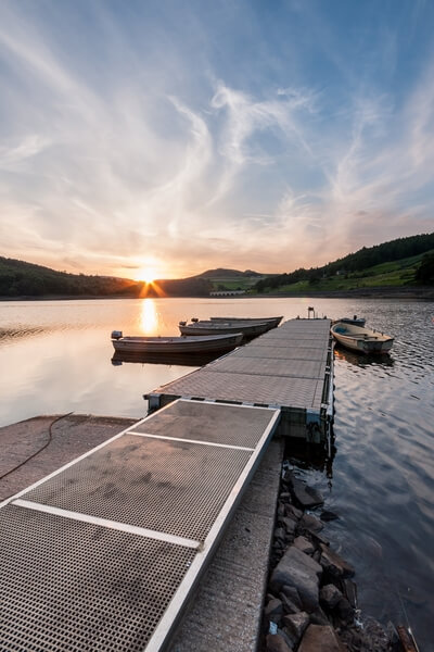
Ladybower Jetty
Ladybower Reservoir is a large Y-shaped
reservoir in the Upper Derwent Valley near Bamford. It is a beautiful location and easily accessible by all. At times you would be forgiven for forgetting that the area was crafted by man. It is perhaps one of the closest examples to a lake the Peak District has. Ladybower wasn’t constructed without controversy. Built between 1935 and 1943, it was built to provide water to Manchester and
Sheffield as well as the East Midlands.
It continues to fulfil this role to this day.
However, this was at the cost of the villages of Ashopton and Derwent.
The buildings were demolished except for the church, which could be seen during low water until 1947 when it was also demolished. At the north of Ladybower is Derwent Reservoir. The reservoir’s dam was used as practice runs for the Dam Busters in World War II, due to the
similar construction of the German dams.
Roughly every 5 years an anniversary flight passes over Derwent and Ladybower Reservoir.
Learn more about Ladybower Jetty
reservoir in the Upper Derwent Valley near Bamford. It is a beautiful location and easily accessible by all. At times you would be forgiven for forgetting that the area was crafted by man. It is perhaps one of the closest examples to a lake the Peak District has. Ladybower wasn’t constructed without controversy. Built between 1935 and 1943, it was built to provide water to Manchester and
Sheffield as well as the East Midlands.
It continues to fulfil this role to this day.
However, this was at the cost of the villages of Ashopton and Derwent.
The buildings were demolished except for the church, which could be seen during low water until 1947 when it was also demolished. At the north of Ladybower is Derwent Reservoir. The reservoir’s dam was used as practice runs for the Dam Busters in World War II, due to the
similar construction of the German dams.
Roughly every 5 years an anniversary flight passes over Derwent and Ladybower Reservoir.
Derwent Reservoir
In the Upper Derwent Valley there are three reservoirs; Ladybower, Derwent and
Howden. Howden takes its water from near the source of the River Derwent before passing it down. The reservoirs provide almost all of Derbyshire’s water as well as some of South Yorkshire and further afield to Manchester, Nottingham and Leicester. Derwent Reservoir and most notably the dam is very well known for its part in the testing of the Dam Busters’ runs in World War II. Planned flyovers have been run roughly every 5 years to commemorate the Battle of Britain using a Lancaster Bomber and Spitfires.
While these three reservoirs are man-made, the area itself is of outstanding beauty and at times you would be forgiven if you were fooled into thinking it was all natural. Derwent Edge dominates the skyline while lower slopes around are lined with larch trees below.
Learn more about Derwent Reservoir
Howden. Howden takes its water from near the source of the River Derwent before passing it down. The reservoirs provide almost all of Derbyshire’s water as well as some of South Yorkshire and further afield to Manchester, Nottingham and Leicester. Derwent Reservoir and most notably the dam is very well known for its part in the testing of the Dam Busters’ runs in World War II. Planned flyovers have been run roughly every 5 years to commemorate the Battle of Britain using a Lancaster Bomber and Spitfires.
While these three reservoirs are man-made, the area itself is of outstanding beauty and at times you would be forgiven if you were fooled into thinking it was all natural. Derwent Edge dominates the skyline while lower slopes around are lined with larch trees below.
Win Hill
Win Hill is one of the most recognisable
hills in the Peak District. It stands proud
and separate from most hills with its almost pyramid shaped top which is instantly identified from most angles, even from many miles away. It is located on the shores of Ladybower Reservoir where its slopes rise steeply up towards the summit.
In legend, Win Hill got its name from the Battle of Win Hill and Lose Hill in 626 A.D. Lose Hill is another familiar hill in the Peak District, located next to Win Hill separated by the valley that runs into Edale. Apparently King Cyengils of Wessex with superior forces on Lose Hill tried to storm Win Hill and the Northumbrians occupying it. The Northumbrians won the battle by rolling large boulders down the hill
and hence the names Win Hill and Lose Hill. The battle may just be a myth as there is no written record from the time that dates it.
Learn more about Win Hill
hills in the Peak District. It stands proud
and separate from most hills with its almost pyramid shaped top which is instantly identified from most angles, even from many miles away. It is located on the shores of Ladybower Reservoir where its slopes rise steeply up towards the summit.
In legend, Win Hill got its name from the Battle of Win Hill and Lose Hill in 626 A.D. Lose Hill is another familiar hill in the Peak District, located next to Win Hill separated by the valley that runs into Edale. Apparently King Cyengils of Wessex with superior forces on Lose Hill tried to storm Win Hill and the Northumbrians occupying it. The Northumbrians won the battle by rolling large boulders down the hill
and hence the names Win Hill and Lose Hill. The battle may just be a myth as there is no written record from the time that dates it.
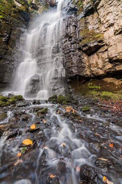
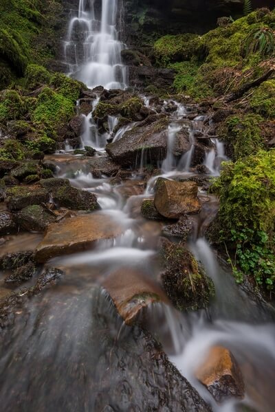
Swallet Falls
Swallet Falls or Waterfall Swallet is an almost secret and hidden waterfall, between the villages of Eyam and Foolow.
It is nestled in a deep hollow, by the roadside but it would pass most by as the falls aren’t visible from here. Dropping down, you feel like you have entered another world in this little cool microclimate. Sheer, moss covered, limestone rock faces surround you, while the water cascades down before eventually running underground.
This really is a special place to visit that was only opened up to the public in 2014 and offers up photographic opportunities previously not allowed.
Learn more about Swallet Falls
It is nestled in a deep hollow, by the roadside but it would pass most by as the falls aren’t visible from here. Dropping down, you feel like you have entered another world in this little cool microclimate. Sheer, moss covered, limestone rock faces surround you, while the water cascades down before eventually running underground.
This really is a special place to visit that was only opened up to the public in 2014 and offers up photographic opportunities previously not allowed.
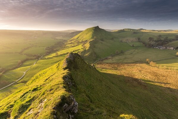
Parkhouse Hill
The Peak District is a strange name for a National Park consisting of moors, tors and flat tops. Nestled in the Upper Dove Valley, though, are the two true peaks of Chrome Hill and Parkhouse Hill. Both of the hills are reef knolls, once submerged under water in the Carboniferous period.
Parkhouse Hill, while being the smaller of the two offers more of an experience with a narrow ledged walk with exposed views from the top.
Learn more about Parkhouse Hill
Parkhouse Hill, while being the smaller of the two offers more of an experience with a narrow ledged walk with exposed views from the top.
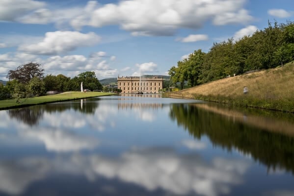
Chatsworth House and Gardens
Chatsworth House is the Peak District’s premier stately home and often voted the
UK’s most popular country house. The house is situated just under 4 miles away from Bakewell, in the rolling landscape of the Derwent Valley.
The main house itself was originally completed in the 1560s, though many alterations have been made since then, to showcase how it is today. The extent to which the estate was designed, went as far as diverting the River Derwent that runs through the park to fit the feel of the area. Such beauty has led to it being used in films such as Pride and Prejudice. Over 300,000 people visit and enjoy the
gardens within the house grounds each year.
Nowadays, the area is a beauty spot for all to enjoy. The park is 1,000 acres, with the majority of it being free of charge to visit. There is an entrance fee to enter the gardens and house, but they offer further photographic opportunities and well worth a visit.
Learn more about Chatsworth House and Gardens
UK’s most popular country house. The house is situated just under 4 miles away from Bakewell, in the rolling landscape of the Derwent Valley.
The main house itself was originally completed in the 1560s, though many alterations have been made since then, to showcase how it is today. The extent to which the estate was designed, went as far as diverting the River Derwent that runs through the park to fit the feel of the area. Such beauty has led to it being used in films such as Pride and Prejudice. Over 300,000 people visit and enjoy the
gardens within the house grounds each year.
Nowadays, the area is a beauty spot for all to enjoy. The park is 1,000 acres, with the majority of it being free of charge to visit. There is an entrance fee to enter the gardens and house, but they offer further photographic opportunities and well worth a visit.
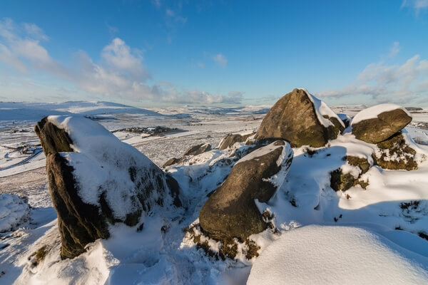
Ramshaw Rocks
Ramshaw Rocks is the instantly recognisable rocky outcrop that stretches high above the A53, its fingers and claws stretch up into the sky. No doubt, if you have travelled on this road from Leek to Buxton, you will have gazed at them as you drove by.
The ridge runs along the A53 from north to south, with dramatic views over the cliff edges across to the east. Combine this with the rolling heather moorlands towards the Roaches and Shutlingsloe in the west and you have a winning combination for multiple opportunities. There are various characterful formations on the edge including the ‘Winking Man’ which is a formation that looks like a face winking at you as you drive up along the A53.
Learn more about Ramshaw Rocks
The ridge runs along the A53 from north to south, with dramatic views over the cliff edges across to the east. Combine this with the rolling heather moorlands towards the Roaches and Shutlingsloe in the west and you have a winning combination for multiple opportunities. There are various characterful formations on the edge including the ‘Winking Man’ which is a formation that looks like a face winking at you as you drive up along the A53.
We hope you enjoy photographing these great The Peak District Instagram locations. We love seeing your images of the most Instagrammable places in The Peak District, so make sure to share your images on PhotoHound and tag us on Instagram @photohound and hashtag #photohound for a chance to be featured.


