YL from the NW Corner of West Thumb
1 images 1 contributors
Lewis Kemper
About this spot
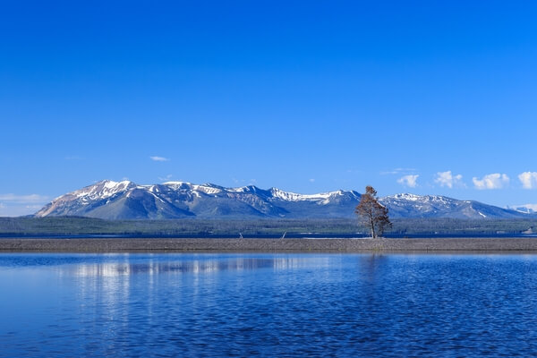
Yellowstone Lake is the largest, high altitude lake (above 7,000) in North America. The lake is approximately 20 miles (32.2 km) long by 14 miles (22.5 km) wide. It has 141 miles (227 km) of shoreline of which only approximately 28 miles is accessible by car. Typically the lake freezes over in late December and thaws in late May or early June. There are many locations to view Yellowstone Lake of which this is just one. Take the time to explore the lake from several locations and at different times of day.
The Grand Loop Road circles around West Thumb, a large bay on the lake. At the northwest corner of this bay there is a sandbar offshore that cuts across that portion of the lake creating a little pool of water. From here you can photograph the pool of water with the sandbar in the middle ground and Mt. Sheridan in the background.
The Grand Loop Road circles around West Thumb, a large bay on the lake. At the northwest corner of this bay there is a sandbar offshore that cuts across that portion of the lake creating a little pool of water. From here you can photograph the pool of water with the sandbar in the middle ground and Mt. Sheridan in the background.
Join PhotoHound to learn how, where and when to capture amazing photos here
- Know the best times, seasons & shooting conditions
- Detailed directions - maps, co-ordinates and directions
- Know how to get there - where to park or how to reach there using public transport
- Browse inspirational photos and learn how they were taken - see the EXIF details
- Bookmark your favourite spots for future reference
- Know exactly when to shoot for beautiful photographs - sunrise, sunset, blue hour and astrophotography
- Detailed, 7-day weather forecast at this location
- Share your images with like-minded travel photographers
Essential Information
Guides
This spot appears in 1 guide.