 St. Magdalene Church on Magdalenska gora
2 images 1 contributors Shoot freely
Aleš Čerin
About this spot
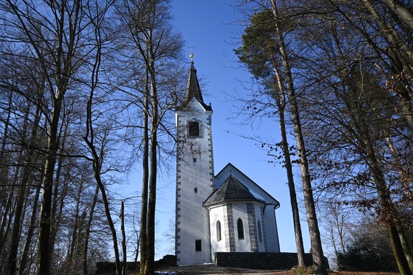
CHURCH OF ST. MAGDALENE
The Church of St Magdalene stands on top of Magdalene Hill, on the site of the acropolis of a former settlement. It is a Gothic building in its basic structure. It was first mentioned in a visitation record from 1663. It says there that it is in a very poor state and 'has neither altar nor money'. Valvasor mentions it among the branches of Šmarje, but does not say anything specific about it. The church is correctly, in the prescribed way, inverted in the floor plan. The nave is rectangular, divided from the chancel by a triumphal arch. The presbytery itself is Gothic, as is the bell tower, which has been added to the south side of the presbytery. The main altar is neo-Gothic, wooden, dedicated to St Magdalene, one of the side altars is named after St Cosmas and Damijan. There are three renowned works of art in the church. On the south wall hangs an image of St Magdalene. She is kneeling by a rock, holding a whip in her right hand and her left hand is resting on her skull. She is looking at a cross planted in the ground, with an open book underneath. The painting is by an unknown artist from the mid-17th century. On the north wall is a painting of the Immaculate Conception by Štefan Šubic in 1860. Of particular historical value is the 20 cm high chalice made of copper and silver. Source: https://zupnija-smarje-sap.rkc.si
IRON AGE SETTLEMENT
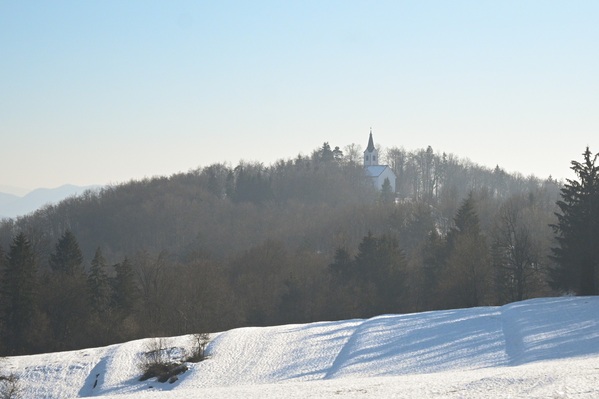
Magdalenska gora is located north of Grosuplje in a small settlement, Zgornja Slivnica, at an altitude of 505 m. Its dominant position meant an excellent communication, defence and economic location for the ancient inhabitants, so that its settlement, understandably, dates back to the Iron Age.
Past archaeological research has shown that the area of Magdalen Hill was continuously inhabited from the Old Iron Age (Hallstatt), through the Celtic invasion, until the Roman occupation period. Its long occupation is confirmed by the 28 clearly visible burial mounds found here, in which hundreds of graves have been excavated.
The settlement structure runs along a north-south axis and is divided into two parts, namely the upper part, where the church of St Magdalene now stands, and the lower part, which is Plato's longest part, running along the tongue of the ridge, ending with the main southern entrance to the settlement. The upper settlement structure was terraced (Kernc, 2019).
The rich archaeological heritage, excavated from numerous graves grouped in large mounds, testifies to the more than 1000 years of occupation of Magdalen Hill. The most valuable and best preserved finds date back to the Iron Age. Among the most important artefacts are: bronze sieves, weapons and other military equipment, various pins and decorative jewellery. A decorative plaque in the shape of a four-armed cross with horse heads is the basis for the image of the Grosuplje municipality coat of arms.
The wider area of Magdalena Gora was once a prehistoric settlement with man-made terraces and defensive embankments. The varied history of archaeological research and the rich finds make Magdalena Gora one of the most famous archaeological sites in Slovenia.
For the first time in the history of Western civilisation (as far back as Greek culture), the wider area of Šmar was permanently inhabited in the 8th century BC on Magdalenska Gora, a hill to the north-east of Šmar. At that time, the valley where Grosuplje or Šmarje is now built was much more marshy. Therefore, the primary settlement at that time was on hilltops. The community that lived here was one of the largest in Dolenjska at that time. It had only one other community, at Vir near Stična. The quantity of tools, weapons, ceramics, etc. found suggests that it was of exceptional commercial and military importance.
It is no coincidence that their settlement here took place in this area. At that time (the Iron Age), iron was increasingly used, and it was practically everywhere on the ground in this area. Their community was hierarchically organised, and their rites of transfer of power can be seen on the situlae found here, as these are the ones that record the rites that took place on this hill 2500 years ago. The community reached its peak in the 5th century BC, but then began to decline over time, before being absorbed into the Roman Empire in the 2nd and 1st centuries BC. Source: https://visitgrosuplje.si
The Church of St Magdalene stands on top of Magdalene Hill, on the site of the acropolis of a former settlement. It is a Gothic building in its basic structure. It was first mentioned in a visitation record from 1663. It says there that it is in a very poor state and 'has neither altar nor money'. Valvasor mentions it among the branches of Šmarje, but does not say anything specific about it. The church is correctly, in the prescribed way, inverted in the floor plan. The nave is rectangular, divided from the chancel by a triumphal arch. The presbytery itself is Gothic, as is the bell tower, which has been added to the south side of the presbytery. The main altar is neo-Gothic, wooden, dedicated to St Magdalene, one of the side altars is named after St Cosmas and Damijan. There are three renowned works of art in the church. On the south wall hangs an image of St Magdalene. She is kneeling by a rock, holding a whip in her right hand and her left hand is resting on her skull. She is looking at a cross planted in the ground, with an open book underneath. The painting is by an unknown artist from the mid-17th century. On the north wall is a painting of the Immaculate Conception by Štefan Šubic in 1860. Of particular historical value is the 20 cm high chalice made of copper and silver. Source: https://zupnija-smarje-sap.rkc.si
IRON AGE SETTLEMENT
Magdalenska gora is located north of Grosuplje in a small settlement, Zgornja Slivnica, at an altitude of 505 m. Its dominant position meant an excellent communication, defence and economic location for the ancient inhabitants, so that its settlement, understandably, dates back to the Iron Age.
Past archaeological research has shown that the area of Magdalen Hill was continuously inhabited from the Old Iron Age (Hallstatt), through the Celtic invasion, until the Roman occupation period. Its long occupation is confirmed by the 28 clearly visible burial mounds found here, in which hundreds of graves have been excavated.
The settlement structure runs along a north-south axis and is divided into two parts, namely the upper part, where the church of St Magdalene now stands, and the lower part, which is Plato's longest part, running along the tongue of the ridge, ending with the main southern entrance to the settlement. The upper settlement structure was terraced (Kernc, 2019).
The rich archaeological heritage, excavated from numerous graves grouped in large mounds, testifies to the more than 1000 years of occupation of Magdalen Hill. The most valuable and best preserved finds date back to the Iron Age. Among the most important artefacts are: bronze sieves, weapons and other military equipment, various pins and decorative jewellery. A decorative plaque in the shape of a four-armed cross with horse heads is the basis for the image of the Grosuplje municipality coat of arms.
The wider area of Magdalena Gora was once a prehistoric settlement with man-made terraces and defensive embankments. The varied history of archaeological research and the rich finds make Magdalena Gora one of the most famous archaeological sites in Slovenia.
For the first time in the history of Western civilisation (as far back as Greek culture), the wider area of Šmar was permanently inhabited in the 8th century BC on Magdalenska Gora, a hill to the north-east of Šmar. At that time, the valley where Grosuplje or Šmarje is now built was much more marshy. Therefore, the primary settlement at that time was on hilltops. The community that lived here was one of the largest in Dolenjska at that time. It had only one other community, at Vir near Stična. The quantity of tools, weapons, ceramics, etc. found suggests that it was of exceptional commercial and military importance.
It is no coincidence that their settlement here took place in this area. At that time (the Iron Age), iron was increasingly used, and it was practically everywhere on the ground in this area. Their community was hierarchically organised, and their rites of transfer of power can be seen on the situlae found here, as these are the ones that record the rites that took place on this hill 2500 years ago. The community reached its peak in the 5th century BC, but then began to decline over time, before being absorbed into the Roman Empire in the 2nd and 1st centuries BC. Source: https://visitgrosuplje.si
Join PhotoHound to learn how, where and when to capture amazing photos here
- Know the best times, seasons & shooting conditions
- Detailed directions - maps, co-ordinates and directions
- Know how to get there - where to park or how to reach there using public transport
- Browse inspirational photos and learn how they were taken - see the EXIF details
- Bookmark your favourite spots for future reference
- Know exactly when to shoot for beautiful photographs - sunrise, sunset, blue hour and astrophotography
- Detailed, 7-day weather forecast at this location
- Share your images with like-minded travel photographers


