Thingvellir National Park
1 images 1 contributors
Raimondo Giamberduca
About this spot
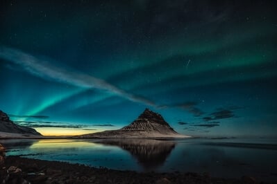
Þingvellir national park is located in the municipality of Bláskógabyggð, about 40 km northeast of Iceland's capital, Reykjavík. Þingvellir is a site of historical, cultural, and geological significance, and is one of the most popular tourist destinations in Iceland. The park lies in a rift valley that marks the crest of the Mid-Atlantic Ridge and the boundary between the North American and Eurasian tectonic plates. To its south lies Þingvallavatn, the largest natural lake in Iceland.
Þingvellir is associated with the national parliament of Iceland, established at the site in 930 AD and remained here until 1798.
It is a World Heritage Site since 2004.
Þingvellir is associated with the national parliament of Iceland, established at the site in 930 AD and remained here until 1798.
It is a World Heritage Site since 2004.
Join PhotoHound to learn how, where and when to capture amazing photos here
- Know the best times, seasons & shooting conditions
- Detailed directions - maps, co-ordinates and directions
- Know how to get there - where to park or how to reach there using public transport
- Browse inspirational photos and learn how they were taken - see the EXIF details
- Bookmark your favourite spots for future reference
- Know exactly when to shoot for beautiful photographs - sunrise, sunset, blue hour and astrophotography
- Detailed, 7-day weather forecast at this location
- Share your images with like-minded travel photographers
Guides
This spot appears in 1 guide.