The East Rim Trail
4 images 1 contributors
Laurent Martres
About this spot
The East Rim Trail cuts across a remote area of the Zion high-country before rejoining civilization in the vicinity of popular landmarks such as Observation Point, Echo Canyon and Hidden Canyon. The final portion of the East Rim Trail, along Echo Canyon is described in the Observation Point Spot.
Although it’s possible to do a round-trip from the East Rim trailhead, it’s much more interesting and enjoyable to do a one-way traverse. However, it requires either having at least two cars, or booking a shuttle with an outfitter in Springdale.
Park car #1 at the Zion Canyon Visitor Center (or at Weeping Rock outside the mandatory shuttle season), drive car #2 to the East Rim Trailhead and start your hike. Or if you book a private shuttle, park your car in the valley and the outfitter will deliver you to the East Rim Trailhead.
The East Rim Trail makes for a pleasant and leisurely 11-mile thru-hike taking about 6 or 7 hours, for the most part completely away from the crowds. Its scenic interest is good but it doesn’t have the same photographic potential as the West Rim spot, unless you do it as a backpacking trip, adding side trips to Observation Point or Hidden Canyon and the longer hikes or overnighters to Cable Mountain and Deertrap Mountain.
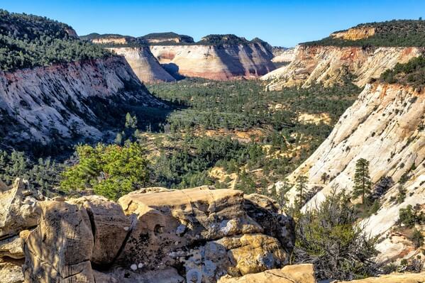
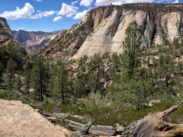
About 2/3rds of this hike is an easy gradual ascent on a very good trail. It begins along Clear Creek and Cave Canyon with great, albeit distant, views of Checkerboard Mesa and Crazy Quilt Mountain (the larger mesa west of Checkerboard). The best views are about 2.2 miles from the trailhead.
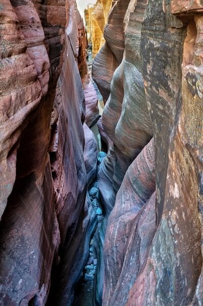
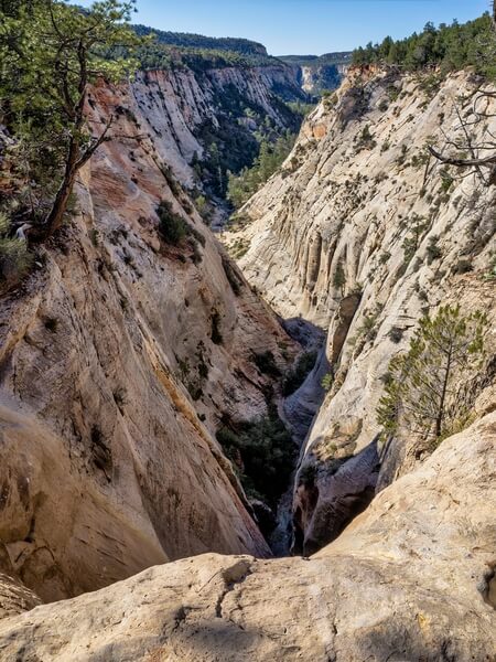
The next interesting viewpoint is the steep chasm of Jolley Gulch at mile 2.9. Be extremely careful around it. If you want to take a peek at the amazing vertical drop-off just below you, the only way is to crawl on all fours. The trail pursues its gradual incline on the plateau after that, with views of Ponderosa Ranch to the northeast, topping off at mile 5.5 shortly before Stave Spring. Things change drastically at mile 7.3 with a steep descent into the upper part of Echo Canyon. There is a very nice viewpoint at 37.277222°, -112.921111° where you can rest a bit and catch views of Echo Canyon. The trail remains somewhat difficult until the junction with the Observation Point Trail, where you rejoin civilization.
Although it’s possible to do a round-trip from the East Rim trailhead, it’s much more interesting and enjoyable to do a one-way traverse. However, it requires either having at least two cars, or booking a shuttle with an outfitter in Springdale.
Park car #1 at the Zion Canyon Visitor Center (or at Weeping Rock outside the mandatory shuttle season), drive car #2 to the East Rim Trailhead and start your hike. Or if you book a private shuttle, park your car in the valley and the outfitter will deliver you to the East Rim Trailhead.
The East Rim Trail makes for a pleasant and leisurely 11-mile thru-hike taking about 6 or 7 hours, for the most part completely away from the crowds. Its scenic interest is good but it doesn’t have the same photographic potential as the West Rim spot, unless you do it as a backpacking trip, adding side trips to Observation Point or Hidden Canyon and the longer hikes or overnighters to Cable Mountain and Deertrap Mountain.
About 2/3rds of this hike is an easy gradual ascent on a very good trail. It begins along Clear Creek and Cave Canyon with great, albeit distant, views of Checkerboard Mesa and Crazy Quilt Mountain (the larger mesa west of Checkerboard). The best views are about 2.2 miles from the trailhead.
The next interesting viewpoint is the steep chasm of Jolley Gulch at mile 2.9. Be extremely careful around it. If you want to take a peek at the amazing vertical drop-off just below you, the only way is to crawl on all fours. The trail pursues its gradual incline on the plateau after that, with views of Ponderosa Ranch to the northeast, topping off at mile 5.5 shortly before Stave Spring. Things change drastically at mile 7.3 with a steep descent into the upper part of Echo Canyon. There is a very nice viewpoint at 37.277222°, -112.921111° where you can rest a bit and catch views of Echo Canyon. The trail remains somewhat difficult until the junction with the Observation Point Trail, where you rejoin civilization.
Join PhotoHound to learn how, where and when to capture amazing photos here
- Know the best times, seasons & shooting conditions
- Detailed directions - maps, co-ordinates and directions
- Know how to get there - where to park or how to reach there using public transport
- Browse inspirational photos and learn how they were taken - see the EXIF details
- Bookmark your favourite spots for future reference
- Know exactly when to shoot for beautiful photographs - sunrise, sunset, blue hour and astrophotography
- Detailed, 7-day weather forecast at this location
- Share your images with like-minded travel photographers
Essential Information
Guides
This spot appears in 1 guide.